


The origin of LiDAR can be traced back to the 1960s. In 1960, after the invention of the ruby laser, LiDAR technology began to gradually develop. In 1962, the Massachusetts Institute of Technology successfully measured the distance between the earth and the moon using LiDAR, and since then the potential value of LiDAR has been continuously discovered by scientists. LiDAR was first used in automobiles in an unmanned vehicle challenge, and since then, vehicle-mounted LiDAR has developed rapidly in the field of intelligent driving.
As the name implies, LiDAR is a radar that works in the optical frequency band. It is a radar system that detects the location, speed and other characteristic quantities of the target by emitting laser beams. Its working process is to first emit an electromagnetic wave detection signal in the optical frequency band toward the target object, and then compare the received signal reflected from the target, that is, the same wave signal, with the transmitted signal, and perform appropriate processing to obtain the target's location, motion state and other characteristic information, thereby realizing the detection and identification of the target. Its maximum detection distance reaches 200 meters. Compared with millimeter wave radar, LiDAR can obtain the three-dimensional shape characteristics of obstacles in addition to the location and speed of obstacles. Therefore, LiDAR can also perform three-dimensional modeling of the vehicle's environment and identify various dynamic and static obstacles.
LiDAR technology is internationally recognized as the foundation of intelligent driving technology. In order to obtain better test results, the optical system of LiDAR has become a research hotspot. LiDAR can provide rich environmental information, which also greatly improves the automatic obstacle avoidance ability of intelligent driving. LiDAR is also an advanced detection method that combines laser technology with modern photoelectric detection technology. It can be divided into transmitting system, receiving system, scanning system and information processing.

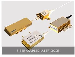
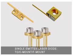
Lasers as its transmitting system are generally composed of carbon dioxide lasers, semiconductor lasers, solid lasers with tunable wavelengths and some optical beam expansion units; the receiving system generally uses a telescope and various forms of photoelectric detectors, such as photomultiplier tubes, semiconductor photodiodes, avalanche photodiodes, infrared and visible light multi-element detection devices. LiDAR uses two working modes: pulse or continuous wave. The detection method can be divided into Mie scattering, Rayleigh scattering, Raman scattering, Brillouin scattering, fluorescence, Doppler and other laser radars according to the different detection principles.
So how does LiDAR achieve distance measurement? We know that the most important part of LiDAR distance measurement is the process of laser emission and reflection. Then, the distance of the target can be calculated by measuring the specific time of this process, that is, the time of the flying laser. Then, according to the emission signals of different lasers, it can be divided into pulse laser ranging and phase laser ranging.
Pulse laser ranging simply means that LiDAR records the time interval between the emission of a laser beam reflected by the measured object and received by the receiver. According to the known speed of light, the measured distance can be calculated. The specific calculation relationship is as follows:
D=CT/2 (1)
Where: D is the detection distance; T is the flight time; C is the speed of light. Phase laser ranging involves the problem of amplitude modulation of the laser signal. The amplitude of the modulated light will change periodically over time. Therefore, we can measure the emission and reflection phase changes of the modulated laser to obtain information about time and distance. The laser radar rotates at a constant speed at a certain speed and continuously emits infrared lasers, while receiving laser signals from reflection points, including information such as the distance, time and horizontal angle of the reflection point. We use multiple transmitters to correspond to different vertical angles, and then use these variable data to obtain the location information of the corresponding reflection point. We collect the coordinates of all reflection points collected by the laser radar after rotating 360° into a point cloud, and then we can obtain all-round environmental information.
The mainstream laser radars on the market now have many components and different technical choices for each component, so their corresponding effects and costs are naturally different. According to their different structures, vehicle-mounted laser radars can be divided into mechanical rotating laser radars, hybrid semi-solid laser radars and fully solid-state laser radars. Mechanical rotating laser radar technology is relatively traditional and mature. Its advantages are that it can achieve 360° horizontal field of view scanning of the surrounding environment and its ranging capability is relatively long. However, its equipment is large in size, and its assembly and debugging are relatively complicated. The cost is high and the production cycle is long. The service life of mechanical components is also difficult to meet automotive grade requirements. Hybrid solid-state laser radars are mainly MEMS (micro-vibration mirror) laser radars, and solid-state laser radars are mainly Flash (floodlight array) and OPA (optical phased array). Among them, MEMS laser radars have the advantages of small size, low cost, and easy mass production, making them the most widely used technology products for current autonomous vehicles.
In fact, it is far from enough to rely on laser radar to achieve intelligent driving. When unmanned vehicles face complex road conditions, a large number of sensors are needed to collect and centrally process real-time road conditions so that the vehicle can make a comprehensive analysis to make a decision. Of course, a single, same type of sensor cannot meet the needs of unmanned vehicles for road condition information analysis. The more complex the road environment, the more different types of sensors with their own advantages are needed.

The current L2 level autonomous driving hardware mostly adopts a design consisting of cameras, millimeter wave radars, and ultrasonic radars. Among them, the advantage of the camera component is that it can clearly identify road obstacles, but the camera is actually affected by light intensity; ultrasonic radar is the reversing radar that we use widely in daily life. Its measurement distance is short and it is easily affected by weather; millimeter wave radar has a strong ability to penetrate smoke, so it can make up for the shortcomings of the camera well, and is more used in blind spot monitoring and lane change assistance. Although it can work in strong light environments and can adapt to relatively bad weather conditions, its judgment accuracy will be worse.
Therefore, LiDAR can detect the specific outline, distance and other information of obstacles more accurately, and generally will not misjudge or miss obstacles in front of the vehicle. The effective detection distance of LiDAR is also farther than the previous two. In theory, a sufficiently long detection distance can provide more reaction time for the vehicle information processing center.
Our address
B-1508 Ruiding Mansion,No.200 Zhenhua Rd,Xihu District
Phone Number
0086 181 5840 0345
info@brandnew-china.com
